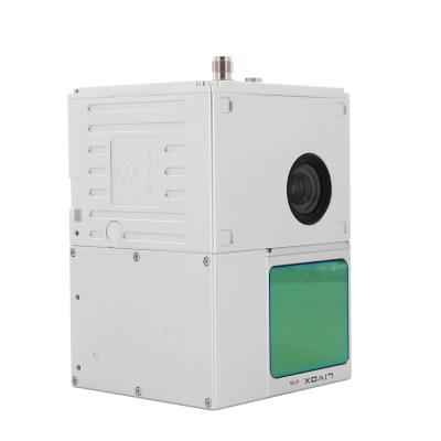
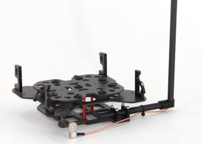
Geosun gAirHawk Series GS-100C+ LiDAR Sistema de digitalização de nível básico Coleta de dados 3D Livox Avia Sensor Supprt UAV Drone
Preço: Negotiation
MOQ: 1
Prazo de entrega: 7-10 works days
Marca: Geosun
Realçar:GS 100C Livox Avia LiDAR, gAirHawk Livox Avia LiDAR, lidar com drone 200HZ
GS-100C+ LIDAR SISTEMA DE VARIFICAÇÃO DO SISTEMA DE ENTRADA DE Coleta de dados 3D Sensor Livox AVIA
Geosun Gairhawk Sesries GS-100C+ Sistema de varredura LIDARO Gairhawk GS-100C+ é um tipo de sistema de aquisição de dados de nuvem de ponto de luz LIDAR, integrado Livox New Generation ... Veja mais
➤ Visita Local na rede Internet
Drone Lidar Scanner Geosun GS-130X Digitalização 3D Câmera RGB Embutida Solução Aérea Total DJI M300 Econômico
Preço: Negotiation
MOQ: 1
Prazo de entrega: 10-15 works days
Marca: Geosun
Realçar:404 Not Found
Drone Lidar Scanner Geosun GS-130X Digitalização 3D Câmera RGB integrada Solução aérea total DJI M300 Custo-benefício
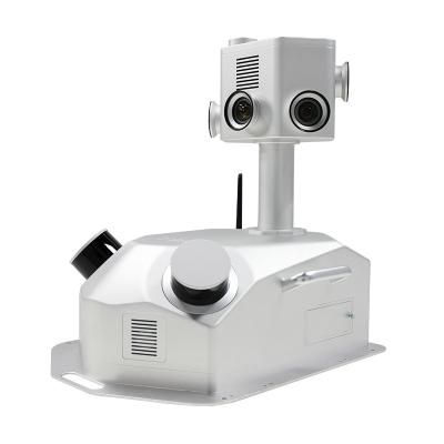
Aplicação do sistema de varredura UAV LiDAR
Drone com LiDAR (DJI M300 e GS-130X)
... Veja mais
➤ Visita Local na rede Internet
Sistema LiDAR de coleta de informações rodoviárias gCollector-M302 em aplicação 3D urbana
Preço: USD 70,000.00/Unit
MOQ: 1
Prazo de entrega: 10-15 works days
Marca: Geosun
Realçar:Sistema LiDAR de coleta de informações rodoviárias, Sistema LiDAR de coleta de informações rodoviárias 3D,
GCOLLECTOR-M302 SISTEMA DE COLLETA DE Coleta de Informações da Estrada
O sistema de coleta de informações da estrada GCollector-M302 éUm sistema de coleta de scense real móvel que integra Lidar, câmeras panorâmicas, GNSS, IMU, WS e PC juntos. Ele pode ser montado em carros, trens ou navios para co... Veja mais
➤ Visita Local na rede Internet

Sistema de monitoramento de deformação GNSS com precisão de 1 mm
MOQ: 2
Prazo de entrega: 10-15 works days
Marca: Geosun
Realçar:Sistema de monitoramento GNSS Geosun 1mm, Sistema de monitoramento de deformação GNSS 1mm, sistema de monitoramento de deformação gráfico 3D
Receptor GNSS de pesquisa de alto desempenho, estação de referência CORS, sistema de monitoramento de deformação
Geosun gMOS é um sistema GNSS de monitoramento de deformação de alta precisão em tempo real que adota a tecnologia de posicionamento dinâmico GNSS de alta precisão em tempo real ava... Veja mais
➤ Visita Local na rede Internet

Sistema GPS BDS GLONASS GNSS INS para posicionamento e altitude
Preço: Negotiation
MOQ: 1
Prazo de entrega: 5-10 Working Days Since Payment
Marca: Geosun
Realçar:Sistema GLONASS GNSS INS, Sistema BDS GNSS INS, Sistema GPS GNSS INS
Sistema GPS BDS GLONASS GNSS INS para posicionamento e altitude
AGS 300Sistema GNSS INS adiciona um módulo de navegação inercial de alta precisão (IMU), não importa como a fuselagem se inclina durante o vôo da aviação, ele pode fornecer informações precisas de posição, velocidade e atitude 3D.
... Veja mais
➤ Visita Local na rede Internet

Software de processamento de trajetória Geosun GNSS INS Shuttle
Preço: Free
MOQ: 1
Prazo de entrega: 1-3 Working Days Since Payment
Marca: Geosun
Realçar:GNSS INS Trajectory Processing Software, Geosun Shuttle Software, Geosun Trajectory Processing Software
Software de transporte com direito de propriedade independente
Software Shuttle com Processo de Trajetória, Software GNSS/INS
Shuttle é um software de pós-processamento de posicionamento e determinação de atitude GNSS/INS de alta precisão, desenvolvido independentemente pela Wuhan Geosun Navigatio... Veja mais
➤ Visita Local na rede Internet
Software de processamento de dados 3D LiDAR com saída de arquivo PT colorida
Preço: Free
MOQ: 1
Prazo de entrega: 1-3 Working Days Since Payment
Marca: Geosun
Realçar:gAirhawk LiDAR Software de processamento de dados, software de processamento LAS de saída de arquivos LiDAR, software de processamento de dados em tempo real
Introdução ao gAirHawk
Software de processamento de dados 3D LiDAR com saída de arquivo colorido PTgAirHawk é um software de monitoramento de aquisição de sistema de varredura lidar e computação em nuvem de pontos desenv... Veja mais
➤ Visita Local na rede Internet
Solução PPK
(1)
Fotografia Topografia Diferencial Cinemático Posicionamento Solução PPK
Preço: Negotiation
MOQ: 1
Prazo de entrega: 5-10 Working Days Since Payment
Marca: Geosun
Realçar:Solução PPK de levantamento fotográfico, solução de PPK de posicionamento diferencial cinemático, instrumentos AG213 PPK
Receptor AGS 213
Aplicação de instrumentos PPK para levantamento e mapeamento fotográfico
Receptor GNSS de antena de alto desempenho
A série AG213 é fabricada pela Geosun spatial, e se especializa na aplicação aérea com baixo consumo de energia e receptor GNSS de alto desempenho, design elaborado... Veja mais
➤ Visita Local na rede Internet
Conjuntos de montagem de drones Geosun DJI M600 - Acessórios LiDAR
Preço: USD 500/SET
MOQ: 1
Prazo de entrega: 1-3 Working Days Since Payment
Marca: Geosun
Realçar:Conjuntos de montagem de drones DJI M600, acessórios Geosun LiDAR, acessórios DJI M600 LiDAR
Kits de montagem para DJI M210, M300, M600 Pro e outras marcas.
Drones DJI são bons aplicativos para levantamento e mapeamento, especialmente para DJI M210, M300 e M600 Pro.É popular e amplamente utilizado por costumes de todo o mundo.
Para combinar com os drones DJI, a Geosun projetou os kits de ... Veja mais
➤ Visita Local na rede Internet
Solução RTK
(2)
ESTAÇÃO BASE/ROVER
Preço: Negotiation
MOQ: 1
Prazo de entrega: 5-10 Working Days Since Payment
Marca: Geosun
Realçar:Solução Receptor GPS RTK, Instrumento 2G Byte RTK, solução 2G Byte RTK
Receptor GPS de instrumentos de levantamento e mapeamento de instrumentos RTK
Ganhe vantagem competitiva com o Receptor Easynavtech R7GNSS.O R7 é equipado com tecnologia avançada para garantir a máxima produtividade no campo.O design IP67 durável torna possível trabalhar em ambientes difíceis.Combi... Veja mais
➤ Visita Local na rede Internet
Drone LiDAR
(2)
Mapeamento Levantamento 3400mm distância entre eixos VTOL Drone LiDAR de asa fixa
Preço: Negotiation
MOQ: 1
Prazo de entrega: 15-20
Marca: Geosun
Realçar:Geosun VTOL Fixed Wing Drone, 2000 mm Wingspan VTOL LiDAR Drone, 2000 mm de envergadura LiDAR Drone
Aplicativo de drone de asa fixa VTOL para mapeamento e pesquisa
O GS-S300 é um drone de asa fixa VTOL elétrico puro, com um design de aparência simples e suave, que permite que o drone navegue a uma velocidade de 90 km/h e tenha uma duração efetiva da bateria de 2,5 horas.Ele pode ser facilmente eq... Veja mais
➤ Visita Local na rede Internet

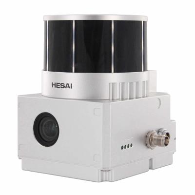
Sistema de digitalização SLAM LiDAR Slam Backpack 3D Digitalização subterrânea interna
Preço: Negotiation
MOQ: 1
Prazo de entrega: 5-7 works days
Marca: Geosun
Realçar:Sistema de digitalização UAV LiDAR portátil, Slam Backpack UAV LiDAR Scanning System, 3D UAV LiDAR Scanning System
GeoSun Gfireeye Series GS-100G Sistema de varredura de lidar GeoSun Gfireeye Series GS-100G LIDAR SISTEMAO GS-100G é uma espécie de sistema de varredura de lidar de mão, desenvolvido independentemente pela GeoSun Company. cenas internas e externas.Solução serial slam.pdf Especificação do sistema... Veja mais
➤ Visita Local na rede Internet